Saturday, December 17, 2011

Penang National Park, Penang, Malaysia

This happens to be my first hike along a coastal line... And, just like every other 'first' in life, this one was lovely.


Penang Island  lies on the north eastern coast of Malaysia. Penang National Park is one of the smallest national parks in the world. The good part is that each of the trails ends in a beach !! After a tough day's hike, all you need is a dip in a scarcely populated beach.


In terms of planning, this hike was exactly like every other 'regular' hike done by me. Everything right from transport to stay to registration was pre-planned. So, here was the plan:

Friday
1000 PM: Leave Singapore for Sungai Nibong (Penang)

Saturday 
730 AM: Arrive Sungai Nibong
930 AM: Arrive Weld quay, take bus 101 to Teluk Bahang
1030 AM: Start hike at Penang National Park
530 PM: Back to guest house

Sunday
900 AM: Back to National Park to complete other trails
400 PM: Take the bus back to Weld quay
730 PM: Return bus for Singapore

Monday
730 AM: Arrive Singapore and go to office !

I am realizing that this itinerary would resemble that of most of the hikes that i plan to undertake in South Asia - Except a few tough ones which might need more time.

Everything went on track and I completed the 4+4 km hike to the light house on Day 1. I had underestimated the effort required - it was much more exhausting than i had anticipated. Humidity was the killing factor because almost the entire trail runs along the beach. Here are some snapshots of the trail to light house.
 
The entrance of Penang National Park
Well marked trails
Some nice resting spots !


Good views along the hike
The Lighthouse

At the top of Lighthouse
Coastline from the lighthouse
Beautiful views from the lighthouse
The next day, I started early and completed the hike to Kerachut beach. If you start really early, right when the park opens, you can have the beach all for yourself for quite some time. By the time i reached Kerachut, there were less than 10 people on the whole beach..

Lake crossing just before the beach
Meromictic Lake (Lake with different layers of Fresh water and Sea water)  

Kerachut beach - Almost noone present early in the morning!!

Kerachut beach is famous for 'nesting turtles' (only specific times of the year)
Turtles routinely visit Kerachut for nesting. This happens only during specific months - However, I was told that camping is restricted at this beach year round. So, I am not sure if you can see them even during the nesting season.

I left the beach post noon so as to spend the afternoon in Georgetown before heading back to Singapore later in the evening.

I would love to come back to Penang to do Penang Hill.. I could not attempt it this time.

Trip specifics:

Singapore - Penang (Sungai Nibong): Many operators ply this route (about 70 SGD for a return ticket) - it takes about 10-11 hours depending on the traffic.

Sungai Nibong - Teluk Bahang: Take bus no 401 to weld quay (every 30 mins b) and then 101 to Teluk bahang (every 15-20 mins)

Budget stay: I stayed at Fisherman's guesthouse - costs about 18 Ringgit for a night. This is as simple as it can get - just a small room for yourself - shared bath/washroom - no a/c. Despite being small, the room was clean. Finding this place might be challenging - Take right just before the park - walk for about 5 mins - keep watching on the right for a small sign board. There is no pre-booking - you have to try your luck.

Where to Eat: I had all my meals at Mom and Pop's cafe - Lovely food - Great hospitality. This is right at the entrance of the park - You will like it.


Up next: Chiang Mai in Northern Thailand (Last week of Jan 2012)


Saturday, November 12, 2011

Mt Gede - Gede-Pangrango National Park, Java, Indonesia

It has been about a month since i have landed here in Singapore and having realized that there is not much i can do within this city, I decided to venture out into Indonesia. Indonesia has some wonderful volcanic peaks that are really enticing...

This hike has by far been the most spontaneous hike ever in my life.. There was no strong plan as has been the case with all my hikes in Canada and US. Madhav, my engg classmate, was in Jakarta and he offered to help me achieve my objective. So here I was, 5 days before the hike, without reservations, travel arrangements, park notfications. I decided to give it a shot with the following plan in mind.

Arrive Jakarta late friday night
Early Saturday morning - leave for trailhead.
Reach trailhead 10AM
Saturday night - Camp at Summit
Sunday evening return to Jakarta
Monday - Jakarta sight seeing
Tuesday morning - return flight to Singapore.

Not knowing what is to come, i assumed i would track to plan as i have in most of the hikes in the past. The journey starts with the first upset - Air Asia flight is delayed. I was able to reach Jakarta only by 130AM local time. On top of this, Madhav, who was supposed to drive me to trailhead was heavily drunk !! The only option was to postpone the hike by a day. We got up late Saturday morning and instead of heading to the trailhead early Sunday, we decided to go find a resort near by on saturday itself so that we can start hiking early on Sunday. It has been a while since i have travelled in a car in India-like environment and this ride was refreshingly pleasant.


Gudang Garam, the cigarette that is the starting point for most smokers in India


Snacks at traffic jams

We were beginning to see peaks at a distance

Madhav, my savior!

Agian, no reservations and we had no clue where we were going to stay. All we had was a 3G ipad which was put to optimal use. We found a resort called Bali Resort in Kota Bunga.

Late in the evening we had a nice full body genuine indonesian massage (it is not what you are thinking!) and I was all set for the hike next day.

We reached the national park at about 930AM and found the park to be locked. Then came a marine, who went in opened it from inside !!

Taman Nasional Gunung Gede Pangrango (Gede Pangrango National Park)

The twin volcanic peaks of Gede and Pangrango

The marine who helped us get in...

Apparently foreigners are mandated to hire a guide and a porter. You can negotiate if you can speak indonesian. But, since i had a ligament tear in my left shoulder i would not have been able to carry overnight camping gear anyways so we decided not to negotiate (Madhav knew a bit of Indonesian). We also met 3 dutch girls who were on a long vacation in Indonesia and were planning to do a 2hr hike on the same route - I offered to take them along till they wanted and they obliged. This way, even i would have company for the first 2 hrs..

Right before we started the hike

I asked the guide if we could stretch and cover both Gede and Pnagrango (Both are 9000ft+ and share the same trail half the way). He said that Pangrango is very risky in the rains and we should not attempt it. We were already into the wet season (Late Oct to Jan) and i too didnt want to take unwarranted risks. So we decided to wind up the hike with Gede only. The plan was to camp at Kadang Badak camp ground (7200Ft) and then do the last 2000ft early in the morning next day so as to witness sunrise at the summit.  

There are some beautiful spots a day hike if you dont have time and resources for a 2 day hike.

Small lake before the waterfall

Waterfall


Closer view of the waterfall

The hike until waterfall is relatively simple and offers some good views. The trail starts gaining some serious elevation progressively. There is a hot spring before Kadang badak camp ground. This is the last spot for day hikers because the trail is pretty steep beyond this point right until the summit.

Vapors coming out of the hot spring


Lots of branches to play with!!

Closer look at the hot spring

This hot spring crossing can be tricky and risky under heavy rains...

Vegetation is dense all through the hike

My guide and I took a crucial call to reduce the length of hike the next day. We decided to camp at the summit rather than at the base camp (Camp ground Kadang Badak). The were some disadvantages of doing so:

Water is available at Kadang Badak but not at the summit
The summit can be really cold and there would be no protection from rain
We might not have company even if we need help...

But, we decided to go ahead so that we could spend more time on the summit the next day. It was already raining and there was not much we could do anyways. 


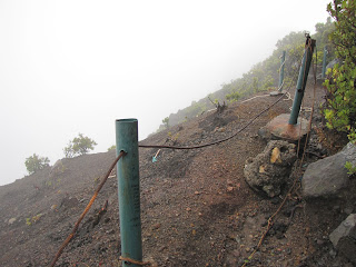
Gede summit when i reached - No visibility at all. The fall from here is right into the center of the volcano crater !

I am not used to somebody else setting up camp and cooking food for me on hikes. Even when we travel in a group, all of us contribute towards something. Here, I was pampered with luxury. The tent was setup when my guide and I reached. Kitchen was setup and boiled water was made avialable for dinner. I kept reminding myself that I must not get used to this - else, i would have trouble when i hike on my own !
Fortunately, it cleared up the next day - we still could not see the sun rise though. Apparently, we were the only ones camping at the summit

The views were outstanding and we could see as far as Jakarta. 

Gede Volcano Crater - it still spews smoke !

Pangrango visible in the background


Romy (Porter) and Isaf (Guide)


Video from the summit

The return hike was a much more relaxed downhill hike, through Suryakencana meadows to Gunung putri.


Suryakencana meadows

I could understand why they dont recommend hiking during rainy season

The view from Gunung Putri

Gede at the distance - From Gunung Putri

Just when i thought i had completed the hike, i realized that i still had a 31/2 hr journey back to Jakarta. Came back in a bus standing on one leg (there was only room for one leg - reminded me of mumbai local trains) for 2 hrs - luckily found a place to sit for the last hour or so.
After reaching Jakarta, i was taken for a ride by a taxi driver - paid him atleast double of what i should have paid. Anyways, all it does is adds more excitement to the trip !!

If you plan to make this hike, here is some information you will find useful:

How to get there:
There are multiple entrances to the park. Cibodas is the most popular entrance - There are frequent buses from Jakarta. I started the hike from Cibodas and exited at Gunung Putri

How much:
Jakarta - Cibodas - 15000-25000 Indonesian Rupees - 3.5 hrs
Porter - atleast 400,000 Indonesian rupees
Guide - atleast 400,000 Indonesian rupees
Rentals - all inclusive ~150,000 (Sleeping bag, tent, kitchen)

This being my first hike in this region, this will always be special !! Currently looking at some more interesting ones both in Indonesia and Malaysia.

Up next: Kota Kinabulu (Malaysia) in Feb/Mar


Sunday, October 23, 2011

Mt Albert - Gaspesie National Park


The 'Chic-Chocs' range has the highest mountains in Quebec. Gaspesie National Park has two of the highest peaks in the region - Mt Jacques Cartier and Mt Albert. Both of these extend well over 1000m and have some really challenging hikes. The trails are physically hard but not technically risky - Believe me, it is pure hard work completing circuits on either of these. These trails are part of the International Apalachian trail (International counterpart of the American Apalachian trail)

Gaspesie National Park is ~750Kms from Montreal and would easily take about 10 hrs by Car and ~12hrs by public transit. As I cut loose on exploration, I have increasingly felt handicapped without a car - It has seriously limited my movement. Nevertheless, I have not missed those with Public transit access !!

Montreal(A) to Gaspesie National Park(B)

I prepared an ambitious solo plan which involved ~1500Kms of bus travel, 17+kms of hiking and a short sleep at a small town near Gaspesie - All in less than 48hrs!! I have a better feel of my stamina (or lack of it!) these days, especially after this busy summer. I am also beginning to like solo hikes !

Here was the plan:

9 AM Saturday: Leave Montreal
9 PM Saturday: Arrive Sainte Anne Des Monts (Small town ~40kms from Gaspesie National Park)
8AM Sunday: Shuttle to Gaspesie National Park
930AM Sunday: Trail head - Mt Albert
5PM Sunday: Shuttle back to Sainte Anne Des Monts
8PM Sunday: Bus to Montreal
8AM Monday: Reach Montreal

The entire itinerary hinged on two key public transits - Bus to Ste Anne Des Monts & Once a day shuttle to Gaspesie National Park. I had to re-hash the whole itinerary when i figured out that the shuttle runs only once a day !

I reach Ste Anne Des Monts on time and checked in at the hotel (Gite La P'tite Falaise) - the hospitality was amazing. It is a home converted into a hotel and it felt like family. Just that we had call an interpreter to converse !! My french is limited to basic greetings and their English was even more limited.. But, finally we figured out a unique way to interact - Google translate !!! I was treated like a guest in their family and it felt great. It was a great start to the trip...

The next morning, I was offered a nice, royal breakfast - This was going to be the biggest meal of the day. It was time to bid adieu - I have not felt bad leaving any other hotel ever in my life, but this one was special.


Ste Anne Des Monts
After finishing registration formalities, I was ready to start my hike. I had met a park official, while I was travelling to the park, who recommended me to do the entire circuit (~17Kms) instead of just doing the summit of Mt Albert (~10+Kms). My only worry was that i had to return on time for the 5PM shuttle - If i missed it, I would be stranded in the middle of the park without a camp site booking, tent and sleeping bag. That was a scary picture !!

But then, I decided to take that risk and started the full circuit.

Near the trail head
There were some amazing views right from the beginning. This range is very similar, in terms of vegetation, to Trans Canada trail that I completed about two weeks back. Trans Canada trail lies to the west of St Lawrence river whereas these mountains are on the east.
As i was gaining elevation, there were some beautiful viewpoints all across the trail. Here are some of the pics:


The summit

I met a 50+ hiker towards the latter half of the trail. He and his 80yr old father do this hike each year religiously and since his father had a medical checkup this year, he handed over the baton to his son. One quality of North Americans that amazes me is their commitment to fitness - This guy (50yr old son) has been hiking for a period that easily exceeds my age. One of the reasons that keep me going is people like him who inspire me each and every time i have hiked in North America.


I admire his commitment

The view from summit was outstanding - you can see the entire range on a clear day. Luckily for me, it was not cloudy enough and i got to see the whole range of Chic chocs.
The view from Summit (1)

The view from Summit (2)

The summit is as flat as it can get.. Since this is a feeding ground of Caribou, they have placed a wooden platform all along the summit so as to not disturb the grass below. We are not supposed to get off the platform - this was respected by everybody.


The return trail has a long patch of rocky stretch - takes a serious toll on your ankles.


 There is a beautiful river crossing (on a bridge) too.


There is a nice lake too - Apparently, this looks really beautiful during winter... You will find its pictures in the visitors center.


All in all, a beautiful hike which had challenges on all fronts - right from travel to communication to the actual hike itself.. Thoroughly enjoyed it.

As it turns out, this one was my last hike in North America. I would start hiking the tropical forests & peaks of South Asia as soon as i get settled down in Singapore.

Bye Bye North America !!